Coombe Brook, April 2018

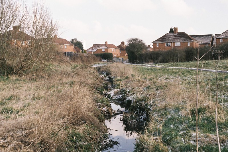
I’m really enjoying using this project to explore places I’ve never been in Bristol, and last Wednesday’s walk with Tracy Homer was a perfect example.  We wanted something not too long and arduous, and I’d had on my list these little runs of water through Speedwell and Clay Bottom, which seemed even more intriguing on the Bristol City Council’s Big Blue Map of Bristol, which shows (most of) the rivers and streams where they run above and below ground, and named this one:  Coombe Brook, aka The Gossey.  It’s only a few kilometres long, but it runs through two very different nature reserves, and even when it’s below ground, its path is a green corridor through the city almost until it reaches the River Frome.  Intriguing in so many ways!

Our walk map is here – with the line of the river very approximately in blue.  I’ve added in our full walk, including heading back along the Bristol-Bath Cycle Path:

And my photo album from the walk is on flickr, or below (if you click or mouse over the first image, it should bring up the slideshow.

Coombe Brook footbridge

So, what did we see?

Continue reading “Coombe Brook, April 2018”

Avon Stories Podcast #21: Photography, film, heritage and more, with Dr Shawn Sobers

I met Shawn Sobers when I was doing my Photography degree at the University of the West of England, and he was one of my professors.  But that’s just one of the many strings to his bow – Shawn is a filmmaker, photographer, writer and curator, and I always found his community-based practice and his range of interests to be completely inspiring.

We went for a walk along the Avon in Lacock, exploring the landscape where Henry Fox Talbot lived and created processes that gave us modern photography.   While we walked, we talked about teaching photography, Shawn’s film practice, his work with National Trust sites helping communities research their links to Transatlantic slavery, and his own role in running a heritage site, curating the Tafari Gallery at Fairfield House, where Emperor Haile Selassie lived in exile in Bath.

Please do forgive the patches of audio problems in the recording.  We were walking in the March snow, on a day full of weather warnings, and it proved a bit too much for my audio equipment!

Find out more about Shawn on his website, which has a selection of films we talked about, including his 1999 film on Haile Selassie, Footsteps of the Emperor, his recent art film about the sinking of the SS Mendi, a ship carrying Black South African Labour Corps troops to serve in World War I, and Under The Bridge, the 1990s film for HTV exploring Transatlantic slavery in Bristol, including the River Avon:

Continue reading “Avon Stories Podcast #21: Photography, film, heritage and more, with Dr Shawn Sobers”

Snowy walk along the closed Avon path

Last Saturday the snow was still around, and I went walking in it with my friends Kate and Tim.  They’d never been down the closed part of the Avon footpath, or seen the Netham Weir, which is there to try to stop the Avon being tidal, so off we went.

Map of our walk:

And photos too.   If you mouse over/click on the first photo it should open the slideshow, or you can go directly to the flickr album.


BOC Gas

Continue reading “Snowy walk along the closed Avon path”

Snow day Avon

Because we’re on the water, and in the south, it doesn’t often snow in Bristol, and if it does, it rarely sticks, so the huge “Beast from the East” snowmaggedon was a huge deal here, that I’m sure people in Scotland and the Frozen North are rolling their eyes at.   But not having to get anywhere, with a warm house and a stocked pantry, it was a ton of fun, just for a weekend.

On Friday Vik and I walked along the Avon and up to Stokeleigh Camp, the Iron Age fort in Leigh Woods, and back.  While the parks and slopes were full of children sledging, once we got to the Avon footpath, it was really empty, with much less traffic on the Portway than usual. All the interesting layers pulled into focus, outlined by snow, from the terraces of Hotwells, to the striations of the Gorge.

Up in the woods it was pretty magical, with everything so quiet we could hear the falling snow hit the evergreen and remaining dead autumn leaves.  We walked around the Fort walls and talked about what it might have been like to live there, as the wind blew swirls of snowflakes off the drifts on top of the earthworks.  As we walked home, a skier passing us on the Nightingale Valley path, the tracks we and others had made were already covered in snow, and it felt like we were the first people to walk on the path, and on the silt banks.  It was a gorgeous day.

Photos are in the album – mouse over/click the first image to get the slideshow, or go straight to flickr.

Striations

Walking the River Trym, February 2018

My friend Tracy Homer puts up with a lot, walking with me, from clambering through ditches and up slopes, to battling knee-high brambles, walking after dark and in torrential rain, and more.  It’s a good thing she likes me, but I don’t want to push my luck, so on Wednesday’s walk with her, we walked a gentle route with no possibility of getting into scrapes – an urban nature exploration, following the River Trym from Southmead, where it first appears in Bristol, to Sea Mills, where it joins the River Avon.

The map of the walk is here:

And the photo album is here (mouse over or click on the first image and it should take you to the slideshow, or click through to flickr)

Looking back to the start of the River Trym, in Southmead

Continue reading “Walking the River Trym, February 2018”

Portishead railway and the footpath to Clevedon

I try not to repeat walks too frequently, but I really loved exploring the disused railway line in Portishead, and it’s ideally a winter walk, as it would be tons harder when covered in undergrowth, and with the plans to reopen the line, I wanted to do it again, while I still can.  So Vik and I went back last Saturday to see the line, and then walk down the footpath along the Bristol Channel to Clevedon.

The map of our walk is here:

and I have an album of photos on flickr, and below.  If you mouse over or click on the first image, it should bring up a slideshow, or use this link.

Portishead lighthouse

Continue reading “Portishead railway and the footpath to Clevedon”

A February walk: “The source of the Malago”, Stanton Drew and Maes Knoll

I’ve been walking a lot, recently, making the most of some free time, and trying to get outdoors as much as possible.  last week, my good friend Tracy Homer and I had a long day out in the hills south of Bristol, starting off looking for the source of Pigeonhouse Stream (aka the source of the Malago, but more on that later) and then getting deep into the history of the area, walking through the hills to the megalithic stone circles at Stanton Drew, and back up to Bristol via Maes Knoll, the Iron Age hill fort on the edge of the city.

Photos from the walk are here – I managed to break two cameras, with my Canon 550D just stopping working, and stupidly dropping my Olympus XA2 35mm, so they end up being just from my mobile, and my friend Cee‘s Olympus OM10….  If you mouse over or click the first photo, you should bring up the slideshow – otherwise the flickr album is here.

The source of Pigeonhouse Stream

Here’s the map of our walk:

Continue reading “A February walk: “The source of the Malago”, Stanton Drew and Maes Knoll”

Trying to walk Colliter’s Brook

This week I wanted to walk Colliter’s Brook, one of the little streams that lead into the Avon.  I haven’t walked it for ages, because the public footpath has been closed off for the (endless) Metrobus works, as the route runs alongside the brook.   But the Metrobus works are finished, so I was hoping it would be opened, because it only crosses in a couple of places – and if they’re not, surely the bus lane can be closed off, like it is around Ashton Avenue Bridge?   I was really excited to get back to the river, because I loved that walk, and I wanted to get all the way up to the Dundry Hills.  So we crossed Winterstoke Road and walked down the path to the railway crossing and the start of the footpath.

Trying to find Colliter's Brook

Continue reading “Trying to walk Colliter’s Brook”

Walking the rails, Portishead to Pill

Back in July, I went to Portishead for the first time, where Dave Chillistone of the Portishead Railway Group took me on a podcast-walk around the town and told me about the history of the Portishead to Bristol railway line, and why it should be re-opened.  One of the things Dave told me about was walking the line to Pill, and I promised myself I’d come back and walk it myself, before the railway was re-opened.   It needs to be walked in the winter, when the summer plants had died back, and Monday turned out to be the perfect day to do it – sunny, cold and dry.

My photos are here (Olympus XA2 35mm point & shoot, Canon 550D DLSR and a couple of iPhone).  If you mouse over or click on the first picture, it should take you to the slideshow, or you can go directly to the flickr album.  And there are words and a map below too.

Gate across the tracks

Continue reading “Walking the rails, Portishead to Pill”